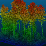
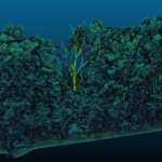
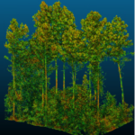
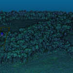
Our state-of-the-art Riegl Vux 240 Light Detection and Range (LiDAR) scanner and PhaseOne large format RGB sensor allow us to deliver high-density, colorized point clouds, representing our latest offering in remote sensing capabilities. Providing innovative and cost-effective solutions for forestry, industrial, agricultural, construction and other markets.
Along with our strategic partners and key clients, we are pioneering ground-breaking methods for improved forest inventory and management. We can provide comprehensive single tree inventories and capture essential forest metrics including tree location, height, height to live crown, crown radius, stem diameter, and taper estimations. Unlike traditional timber inventory methods that can only measure a limited number of trees and rely on interpolation for volume estimation, our lidar approach scans every tree within a stand or plot. This means no tree goes unnoticed, ensuring accurate population values and total stand volume calculations.
Our expertise in LiDAR-based forest inventory extends beyond basic assessments. We specialize in extracting parametric population values and offer tailored solutions for your specific needs. Whether you’re assessing small plots or vast forested areas, our lidar technology delivers unparalleled efficiency and accuracy.
Contact us today to learn more about our lidar solutions and how we can help optimize your forestry management practices.